Geography.
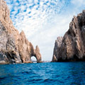
 Los Cabos municipality is located in the southern part of the Baja California peninsula, bordering to the north with La Paz municipality; to the south and east with the Gulf of California and to the west with the Pacific Ocean.
It has an extension of 33 kilometers, 3,451,51 square kilometers of surface that represents 4.68% of the total surface of the state.
On the other hand, the municipal seat is located at the 23° 03 ' north latitude and the 109° 42 ' longitude west of the Greenwich Meridian, at a height of 40 meters above sea level.
The municipality has three different land forms, they are: uneven flat, semi flat and flat areas. The first ones can be located in La Laguna and San Lázaro Sierras, and they are formed by intrusive rocks of the Mesozoic period, granite and batholitic granite. They embrace 15% of the total surface.
The semi flat areas are located between the coast and the mountain, they are formed by sedimentary rocks of the Cretaceous Superior period, and they embrace 60% of the total surface.
Lastly, we locate the flat areas in the coasts, which are formed by marine terraces, gravel, sands and slimes, alluvium deposits, dunes and saltpeter of the Pleistocene period, embracing near 25% of the total surface of the municipality.
Its hydrological resources are scarce, they consist basically in a creek of permanent flow, named San José, which follows a north to south course transferring abundant water during the cyclone rainy season and streams of rain flow that run only during the rainy season such as: Santiago, Miraflores, Caduaño and Las Palmas.
This shortage of water is one of the obstacles for the development of the productive activities in Los Cabos municipality.